Geolocate

Aberawan topographic map

Click on the map to display elevation.

About this map

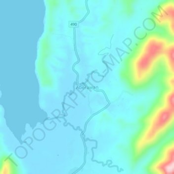
Name: Aberawan topographic map, elevation, terrain.

Location: Aberawan, El Nido, Palawan, Mimaropa, Philippines (11.02450 119.40602 11.06450 119.44602)

Average elevation: 37 m

Minimum elevation: -1 m

Maximum elevation: 258 m

Other topographic maps

Click on a map to view its topography, its elevation and its terrain.

Miniloc Island

Philippines > Palawan > El Nido

Average elevation: 27 m

Shimizu Island

Philippines > Palawan > El Nido

Average elevation: 18 m

South Guntao Island

Philippines > Palawan > El Nido

Average elevation: 7 m

Lio Beach

Philippines > Palawan > El Nido > Villa Libertad

Average elevation: 13 m

Nacpan Beach

Philippines > Palawan > El Nido > Calitang

Average elevation: 36 m

Gear up for your next adventure:

🧭GPS Handheld Device - Reliable GPS navigation for outdoor adventures
🔦UV Flashlight - Detect minerals or specific insects in the dark
🪑Ultralight Camping Stool - Compact seating for rest stops during long hikes
🧊Portable Cooler - Keep food and drinks cold during outdoor adventures
🧰Emergency Multi-Tool - Compact multi-tool for outdoor survival

As an Amazon Associate, this site earns from qualifying purchases at no extra cost to you.