
Make a donation
Gear up for your next adventure:
As an Amazon Associate, this site earns from qualifying purchases at no extra cost to you.
Lamspringe topographic map
Click on the map to display elevation.
Make a donation
Gear up for your next adventure:
As an Amazon Associate, this site earns from qualifying purchases at no extra cost to you.
Lamspringe
Die Ortschaft Lamspringe liegt an der Quelle der Lamme zwischen den Höhenzügen Harplage im Nordosten, Heber im Südosten und dem Sackwald im Westen. Sie befindet sich im Städteviereck Alfeld–Bad Salzdetfurth–Bockenem–Bad Gandersheim.
Make a donation
Gear up for your next adventure:
As an Amazon Associate, this site earns from qualifying purchases at no extra cost to you.
About this map
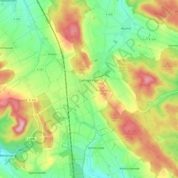
Name: Lamspringe topographic map, elevation, terrain.
Location: Lamspringe, Landkreis Hildesheim, Niedersachsen, Deutschland (51.92736 9.97356 51.98507 10.08841)
Average elevation: 226 m
Minimum elevation: 145 m
Maximum elevation: 335 m
Make a donation
Gear up for your next adventure:
As an Amazon Associate, this site earns from qualifying purchases at no extra cost to you.
Other topographic maps
Click on a map to view its topography, its elevation and its terrain.
Hornsen
Deutschland > Niedersachsen > Landkreis Hildesheim > Lamspringe > Woltershausen
Average elevation: 242 m
Irmenseul
Deutschland > Niedersachsen > Landkreis Hildesheim > Lamspringe > Irmenseul
Average elevation: 240 m
Netze
Deutschland > Niedersachsen > Landkreis Hildesheim > Lamspringe > Woltershausen > Netze
Average elevation: 218 m