
Make a donation
Gear up for your next adventure:
As an Amazon Associate, this site earns from qualifying purchases at no extra cost to you.
Misurinasee topographic map
Click on the map to display elevation.
Make a donation
Gear up for your next adventure:
As an Amazon Associate, this site earns from qualifying purchases at no extra cost to you.
Misurinasee
Der Misurinasee (italienisch Lago di Misurina) ist ein See in den Dolomiten in der Provinz Belluno in Venetien, der seinen Namen aus der Siedlung Misurina annimmt. Die maximale Tiefe des Sees beträgt 5 m. Der 1756 m hoch gelegene See ist vom Südwesten von Cortina d’Ampezzo, vom Höhlensteintal im Norden oder von Auronzo di Cadore, zu dessen Gemeindegebiet der See gehört, im Osten erreichbar. Er ist umgeben von den Felsmassiven der Drei Zinnen, dem Monte Piana, der Cadini-Gruppe, dem Monte Cristallo und weiter im Süden von Marmarole und Sorapiss. An der Südseite des Sees befindet sich das Kurheim „Instituto Pio XII“ (eine Non-Profit-Organisation), das einzige italienische Exzellenzzentrum für Diagnose, Höhenkur und Rehabilitation pädiatrischer Atemwegserkrankungen.
Make a donation
Gear up for your next adventure:
As an Amazon Associate, this site earns from qualifying purchases at no extra cost to you.
About this map
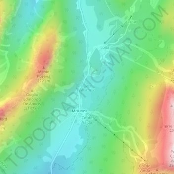
Name: Misurinasee topographic map, elevation, terrain.
Average elevation: 1,904 m
Minimum elevation: 1,680 m
Maximum elevation: 2,370 m
Make a donation
Gear up for your next adventure:
As an Amazon Associate, this site earns from qualifying purchases at no extra cost to you.