
Make a donation
Gear up for your next adventure:
As an Amazon Associate, this site earns from qualifying purchases at no extra cost to you.
Vale do Cobrão topographic map
Click on the map to display elevation.
Make a donation
Gear up for your next adventure:
As an Amazon Associate, this site earns from qualifying purchases at no extra cost to you.
About this map
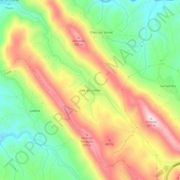
Name: Vale do Cobrão topographic map, elevation, terrain.
Location: Vale do Cobrão, Vila Velha de Ródão, Castelo Branco, Portugal (39.69083 -7.75663 39.73083 -7.71663)
Average elevation: 322 m
Minimum elevation: 140 m
Maximum elevation: 533 m
Make a donation
Gear up for your next adventure:
As an Amazon Associate, this site earns from qualifying purchases at no extra cost to you.
Other topographic maps
Click on a map to view its topography, its elevation and its terrain.
Barragem Romana da Lameira
Portugal > Castelo Branco > Vila Velha de Ródão > Perais
Average elevation: 191 m
Monumento Natural das Portas de Ródão
Portugal > Castelo Branco > Vila Velha de Ródão
Average elevation: 167 m
Make a donation
Gear up for your next adventure:
As an Amazon Associate, this site earns from qualifying purchases at no extra cost to you.
Make a donation
Gear up for your next adventure:
As an Amazon Associate, this site earns from qualifying purchases at no extra cost to you.