Geolocate

Narsingi topographic map

Click on the map to display elevation.

About this map

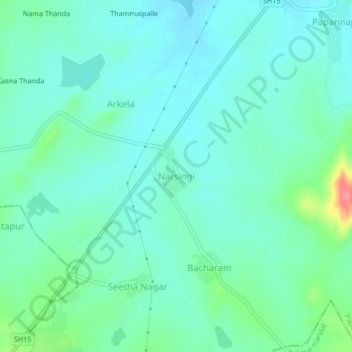
Name: Narsingi topographic map, elevation, terrain.

Location: Narsingi, Papannapet mandal, Medak, Telangana, 502302, India (17.99910 78.04927 18.03910 78.08927)

Average elevation: 455 m

Minimum elevation: 437 m

Maximum elevation: 521 m

Gear up for your next adventure:

👟Trail Running Shoes - Agile footwear for fast-paced topographic exploration
🛶Kayak Dry Bag - Waterproof storage for kayaking adventures
🥾Trail Hiking Shoes - Durable shoes designed for rugged trails
🛌Insulated Sleeping Pad - Critical thermal barrier between you and the cold ground
💧Hydration Bladder - Hands-free hydration solution for long treks

As an Amazon Associate, this site earns from qualifying purchases at no extra cost to you.