
Lech topographic map
Click on the map to display elevation.
Lech
The Lech (Latin: Licus, Licca) is a river in Austria and Germany. It is a right tributary of the Danube 255 kilometres (158 mi) in length with a drainage basin of 3,919 square kilometres (1,513 sq mi). Its average discharge at the mouth is 115 m3/s (4,100 cu ft/s). Its source is located in the Austrian state of Vorarlberg, where the river rises from lake Formarinsee in the Alps at an altitude of 1,870 metres (6,120 ft). It flows in a north-north-easterly direction and crosses the German border, forming the Lechfall, a 12-metre-high (39 ft) waterfall; afterwards the river enters a narrow gorge (the Lechschlucht). Leaving the Alps, it enters the plains of the Allgäu at Füssen at an elevation of 790 metres (2,580 ft) in the German state of Bavaria, where it used to be the location of the boundary with Swabia. The river runs through the city of Füssen and through the Forggensee, a man-made lake which is drained in winter. Here, it forms rapids and a waterfall.
About this map
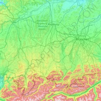
Name: Lech topographic map, elevation, terrain.
Location: Lech, Bavaria, Germany (47.17518 10.00711 48.73534 10.95337)
Average elevation: 795 m
Minimum elevation: 355 m
Maximum elevation: 2,824 m
Other topographic maps
Click on a map to view its topography, its elevation and its terrain.