
Make a donation
Gear up for your next adventure:
As an Amazon Associate, this site earns from qualifying purchases at no extra cost to you.
Varese Ligure topographic map
Click on the map to display elevation.
Make a donation
Gear up for your next adventure:
As an Amazon Associate, this site earns from qualifying purchases at no extra cost to you.
About this map
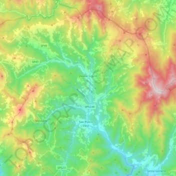
Name: Varese Ligure topographic map, elevation, terrain.
Location: Varese Ligure, La Spezia, Ligurien, Italien (44.28957 9.46574 44.44157 9.67504)
Average elevation: 711 m
Minimum elevation: 221 m
Maximum elevation: 1,619 m
Make a donation
Gear up for your next adventure:
As an Amazon Associate, this site earns from qualifying purchases at no extra cost to you.
Other topographic maps
Click on a map to view its topography, its elevation and its terrain.
Cinque Terre
Italien > Ligurien > La Spezia > Vernazza
Neben den Dörfern selbst ist der Wanderweg Via dell’Amore, der die Dörfer Riomaggiore und Manarola entlang der Küste in moderater Höhe verbindet, die größte Attraktion. Landschaftlich reizvoller ist der anschließende Wanderweg von Manarola über Corniglia und Vernazza nach Monterosso. Hier wandert man…
Average elevation: 221 m
Tellaro
Italien > Ligurien > La Spezia > Lerici
Tellaro liegt 3 km südlich von Lerici direkt am Golf von La Spezia, von wo man über den Golf nach Porto Venere und den vorgelagerten Inseln Palmaria, Tino und Tinetto blickt. Die einzige Zufahrt für Kraftfahrzeuge ist eine nah am Meer gebaute Straße und führt von Lerici über Fiascherino nach Tellaro. Die…
Average elevation: 94 m
Make a donation
Gear up for your next adventure:
As an Amazon Associate, this site earns from qualifying purchases at no extra cost to you.