Geolocate

Jajarkot topographic map

Click on the map to display elevation.

About this map

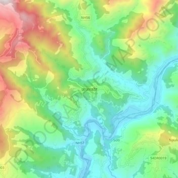
Name: Jajarkot topographic map, elevation, terrain.

Location: Jajarkot, Bheri, Jajarkot, Karnali Province, Nepal (28.65821 82.15826 28.73821 82.23826)

Average elevation: 1,205 m

Minimum elevation: 688 m

Maximum elevation: 2,333 m

Other topographic maps

Click on a map to view its topography, its elevation and its terrain.

Tribeni Nalagad

Nepal > Karnali Province > Jajarkot

Average elevation: 2,428 m

Tribeni Nalagad-08

Nepal > Karnali Province > Jajarkot

Average elevation: 1,907 m

Gear up for your next adventure:

🔦UV Flashlight - Detect minerals or specific insects in the dark
🎒Backpack Rain Cover - External shield to keep your entire pack dry
🧢Hiking Sun Hat - Wide-brimmed protection for exposed mountain ridges
🚑Survival Whistle - Signal for help across long distances in mountains
🌬️Windproof Camp Stove - Efficient cooking even on exposed mountain peaks

As an Amazon Associate, this site earns from qualifying purchases at no extra cost to you.