Geolocate

Groves topographic map

Click on the map to display elevation.

Groves

According to the United States Census Bureau, Groves has an area of 5.2 square miles (13.4 km2), of which 0.015 square miles (0.04 km2), or 0.28%, is water. Most of the city sits at an elevation of 5 to 15 feet (1.5 to 4.6 m) above sea level.

Wikipedia (CC-BY-SA 3.0)

About this map

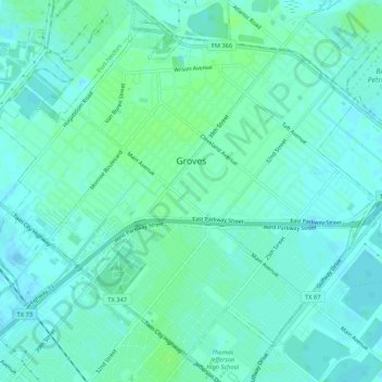
Name: Groves topographic map, elevation, terrain.

Location: Groves, Jefferson County, Texas, 77619, United States (29.92488 -93.94477 29.96423 -93.89173)

Average elevation: 4 m

Minimum elevation: -2 m

Maximum elevation: 9 m

Other topographic maps

Click on a map to view its topography, its elevation and its terrain.

Zummo

United States > Texas > Jefferson County > Beaumont

Average elevation: 6 m

Hamshire

United States > Texas > Jefferson County

Average elevation: 6 m

Beaumont

United States > Texas > Jefferson County > Beaumont

Average elevation: 6 m

Gear up for your next adventure:

🔦UV Flashlight - Detect minerals or specific insects in the dark
🦯Trekking Poles - Reduced impact on joints for steep topographic climbs
🥾Trail Hiking Socks - Comfortable socks to prevent blisters and fatigue
🧴Outdoor Sunscreen - High SPF protection for high-altitude UV exposure
🧥Packable Rain Jacket - Breathable waterproof layer for unpredictable weather

As an Amazon Associate, this site earns from qualifying purchases at no extra cost to you.