Geolocate

Logis-Neuf topographic map

Click on the map to display elevation.

About this map

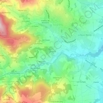
Name: Logis-Neuf topographic map, elevation, terrain.

Location: Logis-Neuf, Vaugneray, Lyon, Rhône, Auvergne-Rhône-Alpes, France métropolitaine, 69670, France (45.70649 4.63488 45.74649 4.67488)

Average elevation: 429 m

Minimum elevation: 288 m

Maximum elevation: 690 m

Other topographic maps

Click on a map to view its topography, its elevation and its terrain.

Vaugneray

France > Auvergne-Rhône-Alpes > Rhône > Vaugneray

Enfin, on notera utilement les références topographique à la commune dans le fichier topographique de Marguerite Gonon.

Average elevation: 448 m

Vaugneray

France > Auvergne-Rhône-Alpes > Rhône > Vaugneray

Average elevation: 473 m

Vaugneray

France > Auvergne-Rhône-Alpes > Rhône > Vaugneray

Average elevation: 473 m

Gear up for your next adventure:

🧣Merino Neck Gaiter - Protects against wind, sun, and cold at high altitudes
🧤Thermal Hiking Gloves - Grip-enhanced gloves for cold-weather altitude trekking
🦶Hiking Shoe Insoles - Added support for high arches and long days on feet
🥾Waterproof Trail Shoes - Shoes designed to handle wet terrain
🥾Waterproof Hiking Shoes - Durable shoes for wet and rugged trails

As an Amazon Associate, this site earns from qualifying purchases at no extra cost to you.