Geolocate

Sialang topographic map

Click on the map to display elevation.

About this map

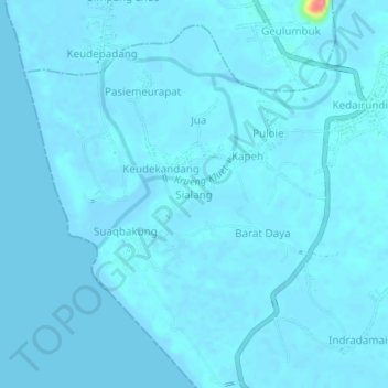
Name: Sialang topographic map, elevation, terrain.

Location: Sialang, Kluet Selatan, Aceh Selatan, Aceh, Sumatra, Indonesia (3.04039 97.30817 3.08039 97.34817)

Average elevation: 3 m

Minimum elevation: -7 m

Maximum elevation: 76 m

Other topographic maps

Click on a map to view its topography, its elevation and its terrain.

Labuhan Haji

Indonesia > Aceh > Aceh Selatan

Average elevation: 1,213 m

Sawang

Indonesia > Aceh > Aceh Selatan

Average elevation: 623 m

Gear up for your next adventure:

🥾Approach Boots - Comfortable boots for hiking and climbing approaches
🔥Emergency Fire Starter - Reliable ignition source for all weather conditions
🚲MTB Frame Bag - Carry tools and maps directly on your bicycle frame
🔋Emergency Crank Radio - Weather alerts and power without needing batteries
🏕️Camping Hammock - Integrated protection for sleeping between trees

As an Amazon Associate, this site earns from qualifying purchases at no extra cost to you.