Geolocate

Kerrville topographic map

Click on the map to display elevation.

About this map

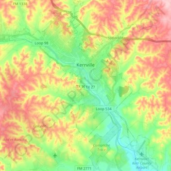
Name: Kerrville topographic map, elevation, terrain.

Location: Kerrville, Kerr County, Texas, United States (29.96182 -99.21161 30.10132 -99.07165)

Average elevation: 545 m

Minimum elevation: 464 m

Maximum elevation: 646 m

Other topographic maps

Click on a map to view its topography, its elevation and its terrain.

Hunt

United States > Texas > Kerr County

Average elevation: 572 m

Mountain Home

United States > Texas > Kerr County

Average elevation: 613 m

Guadalupe River

United States > Texas > Kerr County > Kerrville

Average elevation: 510 m

Camp Verde

United States > Texas > Kerr County

Average elevation: 526 m

Guadalupe River

United States > Texas > Kerr County > Kerrville

Average elevation: 510 m

Center Point

United States > Texas > Kerr County

Average elevation: 471 m

Guadalupe River

United States > Texas > Kerr County > Kerrville

Average elevation: 510 m

Hunt

United States > Texas > Kerr County

Average elevation: 572 m

Hunt

United States > Texas > Kerr County

Average elevation: 572 m

Guadalupe River

United States > Texas > Kerr County > Kerrville

Average elevation: 510 m

Gear up for your next adventure:

🛏️Camping Sleeping Mat - Comfortable mats for sleeping outdoors
🥾Hiking Shoes - Durable and comfortable shoes for trail hiking
🥾Trekking Boots - Durable boots for long-distance trekking
🧦Hiking Liner Socks - Thin base layer to prevent friction and blisters
👟Trail Running Shoes - Agile footwear for fast-paced topographic exploration

As an Amazon Associate, this site earns from qualifying purchases at no extra cost to you.