Geolocate

东关村 topographic map

Click on the map to display elevation.

About this map

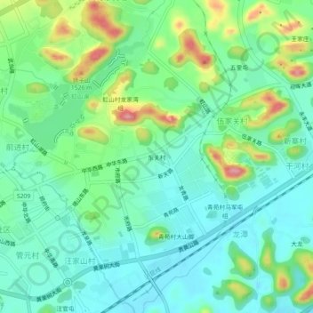
Name: 东关村 topographic map, elevation, terrain.

Location: 东关村, Xixiu, Anshun, Guizhou, 561000, China (26.23341 105.92898 26.27341 105.96898)

Average elevation: 1,387 m

Minimum elevation: 1,346 m

Maximum elevation: 1,488 m

Other topographic maps

Click on a map to view its topography, its elevation and its terrain.

Gear up for your next adventure:

🧊Insulated Water Bottle - Keeps drinks cold in summer and prevents freezing in winter
🕶️Polarized Sunglasses - Reduces glare from snow and water at high elevations
🛶Canoe Life Vest - Safety vest for water sports
📷Outdoor Action Camera - Capture high-elevation views and rugged adventures
🥫Freeze-Dried Meals - Lightweight, high-calorie nutrition for multi-day treks

As an Amazon Associate, this site earns from qualifying purchases at no extra cost to you.