
Make a donation
Gear up for your next adventure:
As an Amazon Associate, this site earns from qualifying purchases at no extra cost to you.
Brochhagen topographic map
Click on the map to display elevation.
Make a donation
Gear up for your next adventure:
As an Amazon Associate, this site earns from qualifying purchases at no extra cost to you.
Brochhagen
Die Topographia Ducatus Montani des Erich Philipp Ploennies, Blatt Amt Steinbach, belegt, dass der dreigeteilte Wohnplatz bereits 1715 drei, vier und nochmals drei Hofstellen besaß, die als Bruchhag beschriftet sind. Im westlich gelegenen Ortsteil ist an der Sülz eine Mühle verzeichnet. Carl Friedrich von Wiebeking benennt die Hofschaften auf seiner Charte des Herzogthums Berg 1789 als Bruchagen.
Make a donation
Gear up for your next adventure:
As an Amazon Associate, this site earns from qualifying purchases at no extra cost to you.
About this map
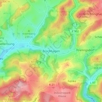
Name: Brochhagen topographic map, elevation, terrain.
Average elevation: 263 m
Minimum elevation: 186 m
Maximum elevation: 360 m
Make a donation
Gear up for your next adventure:
As an Amazon Associate, this site earns from qualifying purchases at no extra cost to you.
Other topographic maps
Click on a map to view its topography, its elevation and its terrain.
51789
Deutschland > Nordrhein-Westfalen > Oberbergischer Kreis > Lindlar > Süttenbach
Average elevation: 237 m