
Thank you for supporting this site ❤️
Make a donation
Make a donation
Gear up for your next adventure:
As an Amazon Associate, this site earns from qualifying purchases at no extra cost to you.
Lierna topographic map
Click on the map to display elevation.
Thank you for supporting this site ❤️
Make a donation
Make a donation
Gear up for your next adventure:
As an Amazon Associate, this site earns from qualifying purchases at no extra cost to you.
About this map
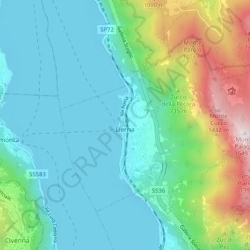
Name: Lierna topographic map, elevation, terrain.
Location: Lierna, Lecco, Lombardije, 23827, Italië (45.94250 9.28360 45.97779 9.35624)
Average elevation: 500 m
Minimum elevation: 189 m
Maximum elevation: 1,518 m
Thank you for supporting this site ❤️
Make a donation
Make a donation
Gear up for your next adventure:
As an Amazon Associate, this site earns from qualifying purchases at no extra cost to you.
Other topographic maps
Click on a map to view its topography, its elevation and its terrain.
Monte Barro
Italië > Lombardije > Lecco > Galbiate
De Monte Barro is een berg nabij Lecco in Lombardije, Italië, met een hoogte van 922 meter.
Average elevation: 411 m