
Thank you for supporting this site ❤️
Make a donation
Make a donation
Gear up for your next adventure:
As an Amazon Associate, this site earns from qualifying purchases at no extra cost to you.
Doğantaş topographic map
Click on the map to display elevation.
Thank you for supporting this site ❤️
Make a donation
Make a donation
Gear up for your next adventure:
As an Amazon Associate, this site earns from qualifying purchases at no extra cost to you.
About this map
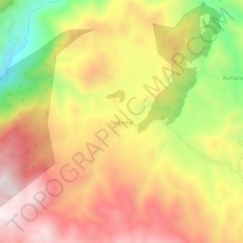
Name: Doğantaş topographic map, elevation, terrain.
Location: Doğantaş, Nazımiye, Tunceli, Oost-Anatolië, 62950, Turkije (39.19679 39.78978 39.23679 39.82978)
Average elevation: 1,638 m
Minimum elevation: 1,120 m
Maximum elevation: 2,031 m
Thank you for supporting this site ❤️
Make a donation
Make a donation
Gear up for your next adventure:
As an Amazon Associate, this site earns from qualifying purchases at no extra cost to you.