Geolocate

Napu topographic map

Click on the map to display elevation.

About this map

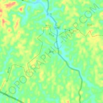
Name: Napu topographic map, elevation, terrain.

Location: Napu, Qinzhou, Guangxi, China (22.50100 108.76200 22.54100 108.80200)

Average elevation: 136 m

Minimum elevation: 112 m

Maximum elevation: 167 m

Other topographic maps

Click on a map to view its topography, its elevation and its terrain.

Maowei Sea

China > Guangxi > Qinzhou

Average elevation: 9 m

Wenfeng Sub-district

China > Guangxi > Qinzhou

Average elevation: 6 m

Gear up for your next adventure:

💧Hydration Pack - Hands-free hydration system for long hikes
🧢Hiking Sun Hat - Wide-brimmed protection for exposed mountain ridges
🔨Vehicle Emergency Tool - Safety tool for remote road trips to trailheads
🏕️Camping Hammock - Integrated protection for sleeping between trees
🎒Fully Waterproof Backpack - Total protection for photography gear and electronics

As an Amazon Associate, this site earns from qualifying purchases at no extra cost to you.