
Make a donation
Gear up for your next adventure:
As an Amazon Associate, this site earns from qualifying purchases at no extra cost to you.
Overwinden topographic map
Click on the map to display elevation.
Make a donation
Gear up for your next adventure:
As an Amazon Associate, this site earns from qualifying purchases at no extra cost to you.
Overwinden
Overwinden ligt op het Haspengouws Plateau op een hoogte van 74-101 meter.
Make a donation
Gear up for your next adventure:
As an Amazon Associate, this site earns from qualifying purchases at no extra cost to you.
About this map
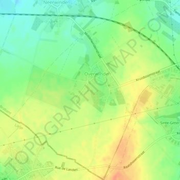
Name: Overwinden topographic map, elevation, terrain.
Location: Overwinden, Landen, Leuven, Vlaams-Brabant, Vlaanderen, België (50.73908 5.02627 50.76598 5.06810)
Average elevation: 83 m
Minimum elevation: 62 m
Maximum elevation: 104 m
Make a donation
Gear up for your next adventure:
As an Amazon Associate, this site earns from qualifying purchases at no extra cost to you.
Other topographic maps
Click on a map to view its topography, its elevation and its terrain.