
Make a donation
Gear up for your next adventure:
As an Amazon Associate, this site earns from qualifying purchases at no extra cost to you.
Southhampton topographic map
Click on the map to display elevation.
Make a donation
Gear up for your next adventure:
As an Amazon Associate, this site earns from qualifying purchases at no extra cost to you.
About this map
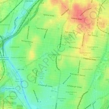
Name: Southhampton topographic map, elevation, terrain.
Location: Southhampton, St. Louis, Missouri, 34324, United States (38.57339 -90.31539 38.61339 -90.27539)
Average elevation: 151 m
Minimum elevation: 123 m
Maximum elevation: 188 m
Make a donation
Gear up for your next adventure:
As an Amazon Associate, this site earns from qualifying purchases at no extra cost to you.
Other topographic maps
Click on a map to view its topography, its elevation and its terrain.
Make a donation
Gear up for your next adventure:
As an Amazon Associate, this site earns from qualifying purchases at no extra cost to you.
Princeton Heights
United States > Missouri > St. Louis
Princeton Heights is an older South St. Louis residential neighborhood. The name "Princeton" came from the old deeds from the neighborhood named Princeton Place Subdivision or Addition. Its outer edge on the west is rather closely paralleled by the River des Peres drainage works, whose valley creates a general…
Average elevation: 143 m
Make a donation
Gear up for your next adventure:
As an Amazon Associate, this site earns from qualifying purchases at no extra cost to you.