Geolocate

Norrfors topographic map

Click on the map to display elevation.

About this map

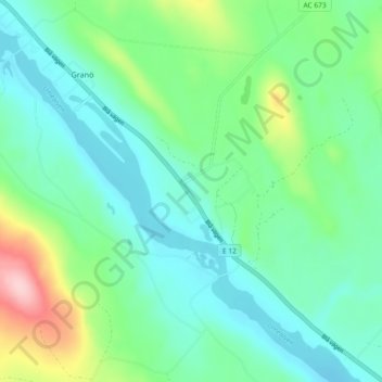
Name: Norrfors topographic map, elevation, terrain.

Location: Norrfors, Granö, Vindelns kommun, Västerbottens län, Sverige (64.21355 19.32938 64.25355 19.36938)

Average elevation: 216 m

Minimum elevation: 172 m

Maximum elevation: 352 m

Gear up for your next adventure:

🧰Survival Kit - Essential gear for emergencies in the wilderness
🗺️Topographic Maps - Detailed maps to explore trails, mountains, and wilderness areas
🌡️Emergency Mylar Blankets - Compact thermal protection for unexpected nights outdoors
🚲Heavy Duty Bike Lock - Secure your bike at the trailhead or during stops
🥾All-Terrain Hiking Boots - Versatile boots for varied hiking conditions

As an Amazon Associate, this site earns from qualifying purchases at no extra cost to you.