
Thank you for supporting this site ❤️
Make a donation
Make a donation
Gear up for your next adventure:
As an Amazon Associate, this site earns from qualifying purchases at no extra cost to you.
Dietmannsried topographic map
Click on the map to display elevation.
Thank you for supporting this site ❤️
Make a donation
Make a donation
Gear up for your next adventure:
As an Amazon Associate, this site earns from qualifying purchases at no extra cost to you.
About this map
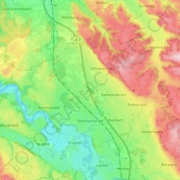
Name: Dietmannsried topographic map, elevation, terrain.
Location: Dietmannsried, Landkreis Oberallgäu, Bavaria, 87463, Germany (47.79009 10.18594 47.86376 10.35298)
Average elevation: 741 m
Minimum elevation: 629 m
Maximum elevation: 900 m
Thank you for supporting this site ❤️
Make a donation
Make a donation
Gear up for your next adventure:
As an Amazon Associate, this site earns from qualifying purchases at no extra cost to you.