
Make a donation
Gear up for your next adventure:
As an Amazon Associate, this site earns from qualifying purchases at no extra cost to you.
Ciudad Obregón topographic map
Click on the map to display elevation.
Make a donation
Gear up for your next adventure:
As an Amazon Associate, this site earns from qualifying purchases at no extra cost to you.
Ciudad Obregón
The city is located on the parallel 27–29' north latitude and the meridian 109-59' west longitude. With an altitude above sea level of 40.8 m (134 ft) in the city center.
Make a donation
Gear up for your next adventure:
As an Amazon Associate, this site earns from qualifying purchases at no extra cost to you.
About this map
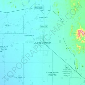
Name: Ciudad Obregón topographic map, elevation, terrain.
Location: Ciudad Obregón, Cajeme, Sonora, 85080, Mexico (27.32466 -110.09378 27.64466 -109.77378)
Average elevation: 59 m
Minimum elevation: 13 m
Maximum elevation: 863 m
Make a donation
Gear up for your next adventure:
As an Amazon Associate, this site earns from qualifying purchases at no extra cost to you.
Other topographic maps
Click on a map to view its topography, its elevation and its terrain.