Geolocate

Dingras topographic map

Click on the map to display elevation.

About this map

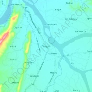
Name: Dingras topographic map, elevation, terrain.

Location: Dingras, Ilocos Norte, Ilocos Region, 2913, Philippines (18.06346 120.65773 18.14346 120.73773)

Average elevation: 41 m

Minimum elevation: 12 m

Maximum elevation: 263 m

Other topographic maps

Click on a map to view its topography, its elevation and its terrain.

MMSU Technology Park

Philippines > Ilocos Norte > Batac

Average elevation: 19 m

Gear up for your next adventure:

🥾Hiking Leggings - Comfortable leggings for outdoor activities
🥽Outdoor Goggles - Protective eyewear for outdoor activities
🧊Portable Cooler - Keep food and drinks cold during outdoor adventures
🛏️Sleeping Bag - Warm and compact sleeping bags for outdoor camping
🧶550 Survival Paracord - Versatile utility cord for emergency repairs and rigging

As an Amazon Associate, this site earns from qualifying purchases at no extra cost to you.