
Armagh topographic map
Click on the map to display elevation.
About this map
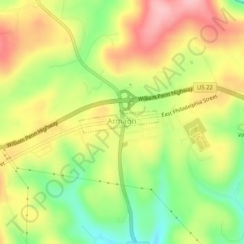
Name: Armagh topographic map, elevation, terrain.
Location: Armagh, Indiana County, Pennsylvania, United States (40.45232 -79.03820 40.45479 -79.02663)
Average elevation: 470 m
Minimum elevation: 390 m
Maximum elevation: 546 m
Other topographic maps
Click on a map to view its topography, its elevation and its terrain.
Dilltown
United States > Pennsylvania > Indiana County > East Wheatfield Township
Average elevation: 474 m
Robinson
United States > Pennsylvania > Indiana County > West Wheatfield Township
Average elevation: 397 m