
Thank you for supporting this site ❤️
Make a donation
Make a donation
Gear up for your next adventure:
As an Amazon Associate, this site earns from qualifying purchases at no extra cost to you.
Alcañiz topographic map
Click on the map to display elevation.
Thank you for supporting this site ❤️
Make a donation
Make a donation
Gear up for your next adventure:
As an Amazon Associate, this site earns from qualifying purchases at no extra cost to you.
About this map
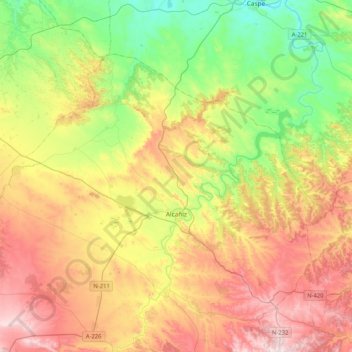
Name: Alcañiz topographic map, elevation, terrain.
Location: Alcañiz, Bajo Aragón, Teruel, Aragon, Spain (40.97551 -0.37625 41.19201 0.03692)
Average elevation: 364 m
Minimum elevation: 108 m
Maximum elevation: 696 m
Thank you for supporting this site ❤️
Make a donation
Make a donation
Gear up for your next adventure:
As an Amazon Associate, this site earns from qualifying purchases at no extra cost to you.