
Thank you for supporting this site ❤️
Make a donation
Make a donation
Gear up for your next adventure:
As an Amazon Associate, this site earns from qualifying purchases at no extra cost to you.
Khajjiar topographic map
Click on the map to display elevation.
Thank you for supporting this site ❤️
Make a donation
Make a donation
Gear up for your next adventure:
As an Amazon Associate, this site earns from qualifying purchases at no extra cost to you.
About this map
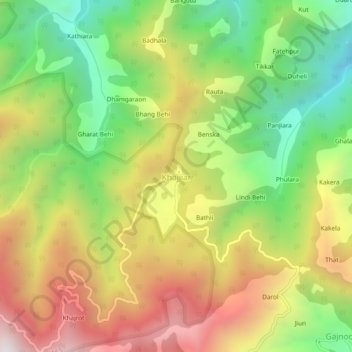
Name: Khajjiar topographic map, elevation, terrain.
Location: Khajjiar, Chamba, Chamba District, Himachal Pradesh, India (32.52857 76.03972 32.56857 76.07972)
Average elevation: 1,868 m
Minimum elevation: 1,279 m
Maximum elevation: 2,547 m
Thank you for supporting this site ❤️
Make a donation
Make a donation
Gear up for your next adventure:
As an Amazon Associate, this site earns from qualifying purchases at no extra cost to you.