Geolocate

Churchill topographic map

Click on the map to display elevation.

About this map

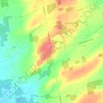
Name: Churchill topographic map, elevation, terrain.

Location: Churchill, Innisfil, Simcoe County, Central Ontario, Ontario, L0L 1W0, Canada (44.23184 -79.62111 44.27184 -79.58111)

Average elevation: 262 m

Minimum elevation: 226 m

Maximum elevation: 299 m

Simcoe County trails, hiking, mountain biking, running and outdoor activities

Other topographic maps

Click on a map to view its topography, its elevation and its terrain.

Gear up for your next adventure:

👟Trail Running Shoes - Agile footwear for fast-paced topographic exploration
🥾Light Trekking Boots - Supportive boots for multi-day treks
🥾Trekking Poles - Adjustable trekking poles to reduce knee stress and improve stability
🧭Orienteering Kit - Tools for map reading and navigation in the wild
🧥Waterproof Hiking Jacket - Protect yourself from rain and wind while hiking

As an Amazon Associate, this site earns from qualifying purchases at no extra cost to you.