
Make a donation
Gear up for your next adventure:
As an Amazon Associate, this site earns from qualifying purchases at no extra cost to you.
Puerto Rico topographic map
Click on the map to display elevation.
Make a donation
Gear up for your next adventure:
As an Amazon Associate, this site earns from qualifying purchases at no extra cost to you.
About this map
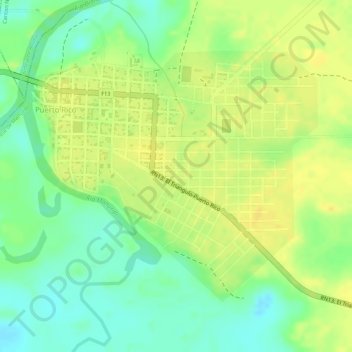
Name: Puerto Rico topographic map, elevation, terrain.
Average elevation: 168 m
Minimum elevation: 152 m
Maximum elevation: 179 m
Make a donation
Gear up for your next adventure:
As an Amazon Associate, this site earns from qualifying purchases at no extra cost to you.
Other topographic maps
Click on a map to view its topography, its elevation and its terrain.
Municipio Puerto Rico
Bolivia > Pando > Provincia de Manuripi
El municipio de Puerto Rico tiene altitud aproximada de 205 metros sobre el nivel del mar. El municipio limita al norte con el municipio de Bella Flor, al sur por el municipio de Sena, al este por el municipio de Santa Rosa del Abuná, y al oeste por el municipio de Filadelfia.
Average elevation: 180 m