
Make a donation
Gear up for your next adventure:
As an Amazon Associate, this site earns from qualifying purchases at no extra cost to you.
Kröv topographic map
Click on the map to display elevation.
Make a donation
Gear up for your next adventure:
As an Amazon Associate, this site earns from qualifying purchases at no extra cost to you.
Kröv
Kröv liegt an der Mosel zwischen der Stadt Traben-Trarbach und Kinheim. Die Gemeinde besteht aus dem Hauptort und dem deutlich kleineren Ortsteil Kövenig, der östlich von Kröv liegt und durch den Höhenrücken des Mont Royal von ihr getrennt wird.
Make a donation
Gear up for your next adventure:
As an Amazon Associate, this site earns from qualifying purchases at no extra cost to you.
About this map
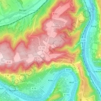
Name: Kröv topographic map, elevation, terrain.
Average elevation: 236 m
Minimum elevation: 89 m
Maximum elevation: 419 m
Make a donation
Gear up for your next adventure:
As an Amazon Associate, this site earns from qualifying purchases at no extra cost to you.
Other topographic maps
Click on a map to view its topography, its elevation and its terrain.
Wederath
Deutschland > Rheinland-Pfalz > Landkreis Bernkastel-Wittlich > Morbach
Average elevation: 524 m