Geolocate

Mund topographic map

Click on the map to display elevation.

Mund

The former municipality is located in the Brig district, on the northern slope of the Rhone valley at an elevation of about 1,200 m (3,900 ft).

Wikipedia (CC-BY-SA 3.0)

About this map

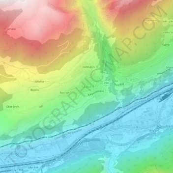
Name: Mund topographic map, elevation, terrain.

Location: Mund, Naters, Brig, Wallis, 3903, Switzerland (46.29529 7.92110 46.33529 7.96110)

Average elevation: 1,250 m

Minimum elevation: 650 m

Maximum elevation: 2,353 m

Other topographic maps

Click on a map to view its topography, its elevation and its terrain.

Naters

Switzerland > Wallis > Brig

Average elevation: 2,164 m

Gear up for your next adventure:

🥾Trekking Boots - Durable boots for long-distance trekking
🚲Bike Repair Kit - Essential tools for on-trail mechanical issues
🧥Insulated Jacket - Keep warm in cold outdoor conditions
🥘Camping Cookware Set - Compact nesting pots and pans for trail cooking
🔨Vehicle Emergency Tool - Safety tool for remote road trips to trailheads

As an Amazon Associate, this site earns from qualifying purchases at no extra cost to you.