
Make a donation
Gear up for your next adventure:
As an Amazon Associate, this site earns from qualifying purchases at no extra cost to you.
Alta Vista topographic map
Click on the map to display elevation.
Make a donation
Gear up for your next adventure:
As an Amazon Associate, this site earns from qualifying purchases at no extra cost to you.
Alta Vista
Alta Vista was founded in 1887, and it was incorporated as a city in 1905. Alta Vista is derived from the Spanish word for "high view", and the city was so named from its lofty elevation.
Make a donation
Gear up for your next adventure:
As an Amazon Associate, this site earns from qualifying purchases at no extra cost to you.
About this map
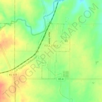
Name: Alta Vista topographic map, elevation, terrain.
Location: Alta Vista, Wabaunsee County, Kansas, United States (38.85509 -96.49469 38.86970 -96.48283)
Average elevation: 443 m
Minimum elevation: 418 m
Maximum elevation: 465 m
Make a donation
Gear up for your next adventure:
As an Amazon Associate, this site earns from qualifying purchases at no extra cost to you.
Other topographic maps
Click on a map to view its topography, its elevation and its terrain.
Mount Mitchell Heritage Prairie Park
United States > Kansas > Wabaunsee County > Wamego
Average elevation: 325 m