Geolocate

Satta topographic map

Click on the map to display elevation.

About this map

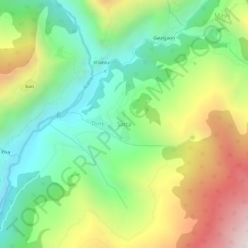
Name: Satta topographic map, elevation, terrain.

Location: Satta, Mori, Uttarkashi, Uttarakhand, India (31.13005 78.08479 31.17005 78.12479)

Average elevation: 2,140 m

Minimum elevation: 1,598 m

Maximum elevation: 3,015 m

Gear up for your next adventure:

🔭Outdoor Binoculars - Lightweight binoculars for birdwatching and hiking
🧊Insulated Water Bottle - Keeps drinks cold in summer and prevents freezing in winter
🥾Trekking Poles - Adjustable trekking poles to reduce knee stress and improve stability
🧤Thermal Hiking Gloves - Grip-enhanced gloves for cold-weather altitude trekking
🧥Waterproof Hiking Jacket - Protect yourself from rain and wind while hiking

As an Amazon Associate, this site earns from qualifying purchases at no extra cost to you.