Geolocate

Balipara topographic map

Click on the map to display elevation.

About this map

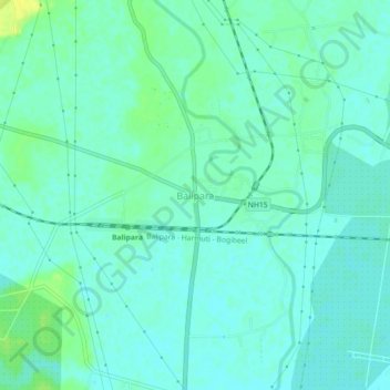
Name: Balipara topographic map, elevation, terrain.

Location: Balipara, Chariduar, Sonitpur, Assam, 784101, India (26.80253 92.75987 26.84253 92.79987)

Average elevation: 80 m

Minimum elevation: 74 m

Maximum elevation: 92 m

Other topographic maps

Click on a map to view its topography, its elevation and its terrain.

Pakke/Pakhui WLS/Tiger Reserve

India > Assam > Chariduar

Average elevation: 636 m

Gear up for your next adventure:

🎒Hiking Backpack - Lightweight and ergonomic backpacks for day hikes or multi-day treks
🚲Bike Repair Kit - Essential tools for on-trail mechanical issues
🧥Thermal Layer - Insulating layer for cold outdoor conditions
🥾Waterproof Hiking Boots - Boots keeping your feet dry in wet conditions
🦯Trekking Poles - Reduced impact on joints for steep topographic climbs

As an Amazon Associate, this site earns from qualifying purchases at no extra cost to you.