Geolocate

Rossano topographic map

Click on the map to display elevation.

About this map

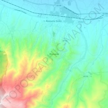
Name: Rossano topographic map, elevation, terrain.

Location: Rossano, Corigliano-Rossano, Cosenza, Calabria, 87064, Italy (39.53502 16.59334 39.61502 16.67334)

Average elevation: 265 m

Minimum elevation: 3 m

Maximum elevation: 1,026 m

Other topographic maps

Click on a map to view its topography, its elevation and its terrain.

Tarsia

Italy > Calabria > Cosenza

Average elevation: 181 m

Longobardi

Italy > Calabria > Cosenza

Average elevation: 315 m

Gear up for your next adventure:

🥤Collapsible Travel Cup - Saves space and weight in your mess kit
🥾Trail Hiking Socks - Comfortable socks to prevent blisters and fatigue
🥾Trail Running Shoes - Lightweight and durable shoes for trail running
🪑Insulated Seat Pad - Protect your seat from cold rocks and wet logs
🧭Orienteering Kit - Tools for map reading and navigation in the wild

As an Amazon Associate, this site earns from qualifying purchases at no extra cost to you.