Geolocate

Lucca topographic map

Click on the map to display elevation.

About this map

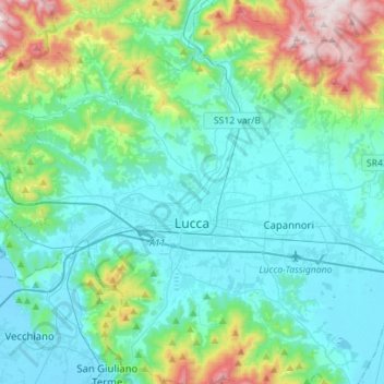
Name: Lucca topographic map, elevation, terrain.

Location: Lucca, Tuscany, Italy (43.75829 10.36274 43.96009 10.57376)

Average elevation: 192 m

Minimum elevation: -4 m

Maximum elevation: 991 m

Other topographic maps

Click on a map to view its topography, its elevation and its terrain.

Ponteccio

Italy > Tuscany > Lucca

Average elevation: 1,036 m

Gear up for your next adventure:

🧤Insulated Winter Gloves - Heavy-duty protection for sub-zero Canadian adventures
🧤Thermal Hiking Gloves - Grip-enhanced gloves for cold-weather altitude trekking
🧭GPS Tracker - Track your location in remote areas safely
🥾Trekking Poles - Adjustable trekking poles to reduce knee stress and improve stability
🧢Hiking Sun Hat - Wide-brimmed protection for exposed mountain ridges

As an Amazon Associate, this site earns from qualifying purchases at no extra cost to you.