
Make a donation
Gear up for your next adventure:
As an Amazon Associate, this site earns from qualifying purchases at no extra cost to you.
Purkersdorf topographic map
Click on the map to display elevation.
Make a donation
Gear up for your next adventure:
As an Amazon Associate, this site earns from qualifying purchases at no extra cost to you.
About this map
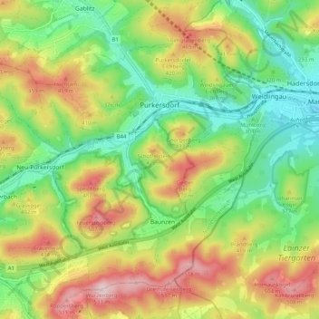
Name: Purkersdorf topographic map, elevation, terrain.
Location: Purkersdorf, Bezirk St. Pölten, Lower Austria, 3002, Austria (48.16886 16.10942 48.22350 16.20962)
Average elevation: 351 m
Minimum elevation: 218 m
Maximum elevation: 538 m
Make a donation
Gear up for your next adventure:
As an Amazon Associate, this site earns from qualifying purchases at no extra cost to you.
Other topographic maps
Click on a map to view its topography, its elevation and its terrain.
Kirchberg an der Pielach
Austria > Lower Austria > Bezirk St. Pölten > Gemeinde Kirchberg an der Pielach > Kirchberg an der Pielach
Average elevation: 480 m
Sois
Austria > Lower Austria > Bezirk St. Pölten > Gemeinde Kirchberg an der Pielach
Average elevation: 494 m