Geolocate

Barota topographic map

Click on the map to display elevation.

About this map

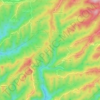
Name: Barota topographic map, elevation, terrain.

Location: Barota, Baroh, Kangra, Himachal Pradesh, India (32.03748 76.33529 32.07748 76.37529)

Average elevation: 813 m

Minimum elevation: 699 m

Maximum elevation: 940 m

Gear up for your next adventure:

🥾Trail Hiking Socks - Comfortable socks to prevent blisters and fatigue
🎒Backpack Rain Cover - External shield to keep your entire pack dry
🧊Portable Cooler - Keep food and drinks cold during outdoor adventures
Lightweight Camping Tent - Portable shelter optimized for Canadian backcountry camping
💧Reusable Water Bottle - Durable water bottles for hydration on trails

As an Amazon Associate, this site earns from qualifying purchases at no extra cost to you.