Geolocate

Fuendecampo topographic map

Click on the map to display elevation.

About this map

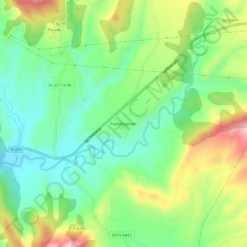
Name: Fuendecampo topographic map, elevation, terrain.

Location: Fuendecampo, La Fueva, Sobrarbe, Huesca, Aragón, 22337, España (42.39281 0.24622 42.43281 0.28622)

Average elevation: 696 m

Minimum elevation: 583 m

Maximum elevation: 895 m

Other topographic maps

Click on a map to view its topography, its elevation and its terrain.

Boltaña

España > Aragón > Sobrarbe

Average elevation: 859 m

Tella-Sin

España > Aragón > Sobrarbe

Average elevation: 1,448 m

Embalse de Mediano

España > Aragón > Sobrarbe

Average elevation: 649 m

La Fueva

España > Aragón > Sobrarbe

Average elevation: 923 m

Cañón de Añisclo

España > Aragón > Sobrarbe

Average elevation: 1,487 m

Gear up for your next adventure:

🔭Outdoor Binoculars - Lightweight binoculars for birdwatching and hiking
🦶Anti-Blister Balm - Prevents friction and hotspots during long ascents
🔋Emergency Crank Radio - Weather alerts and power without needing batteries
💡LED Camping Lantern - Illuminate your campsite with long-lasting lanterns
🧢Sun Hat - Wide-brim hat for sun protection

As an Amazon Associate, this site earns from qualifying purchases at no extra cost to you.