Geolocate

Les Granxes topographic map

Click on the map to display elevation.

About this map

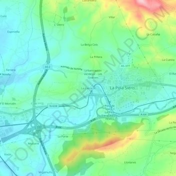
Name: Les Granxes topographic map, elevation, terrain.

Location: Les Granxes, La Pola Siero, Siero, Asturias, 33510, Spain (43.37131 -5.69153 43.41131 -5.65153)

Average elevation: 241 m

Minimum elevation: 189 m

Maximum elevation: 387 m

Gear up for your next adventure:

💡Compact LED Flashlight - Powerful and portable flashlight for outdoor use
🥾Waterproof Hiking Boots - Boots keeping your feet dry in wet conditions
Camping Tent - Weather-resistant tents suitable for 2 to 6 people
🧦Hiking Liner Socks - Thin base layer to prevent friction and blisters
🧭GPS Handheld Device - Reliable GPS navigation for outdoor adventures

As an Amazon Associate, this site earns from qualifying purchases at no extra cost to you.