Geolocate

Lincoln topographic map

Click on the map to display elevation.

About this map

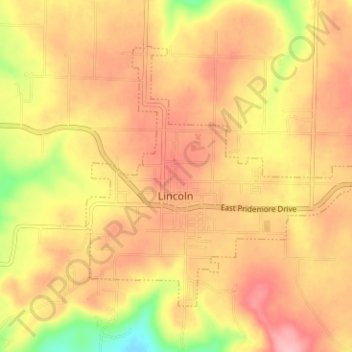
Name: Lincoln topographic map, elevation, terrain.

Location: Lincoln, Washington County, Arkansas, United States (35.93349 -94.43942 35.97113 -94.37659)

Average elevation: 436 m

Minimum elevation: 358 m

Maximum elevation: 482 m

Other topographic maps

Click on a map to view its topography, its elevation and its terrain.

Durham

United States > Arkansas > Washington County

Average elevation: 411 m

Sonora

United States > Arkansas > Washington County

Average elevation: 388 m

Pinnacle

United States > Arkansas > Washington County

Average elevation: 360 m

Wyman

United States > Arkansas > Washington County

Average elevation: 377 m

Canehill

United States > Arkansas > Washington County

Average elevation: 446 m

Savoy

United States > Arkansas > Washington County

Average elevation: 348 m

Sunset

United States > Arkansas > Washington County

Average elevation: 628 m

Strickler

United States > Arkansas > Washington County

Average elevation: 486 m

Hogeye

United States > Arkansas > Washington County

Average elevation: 414 m

Gear up for your next adventure:

🧥Fleece Jacket - Warm and lightweight jacket for layering
🎒Fully Waterproof Backpack - Total protection for photography gear and electronics
🧥Softshell Hiking Jacket - The perfect balance of wind protection and breathability
🧭Orienteering Kit - Tools for map reading and navigation in the wild
🥾Durable Hiking Shoes - Long-lasting shoes for frequent hiking

As an Amazon Associate, this site earns from qualifying purchases at no extra cost to you.