Geolocate

Winrock topographic map

Click on the map to display elevation.

About this map

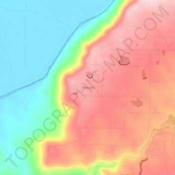
Name: Winrock topographic map, elevation, terrain.

Location: Winrock, Conway County, Arkansas, United States (35.11814 -92.96378 35.15814 -92.92378)

Average elevation: 220 m

Minimum elevation: 88 m

Maximum elevation: 349 m

Other topographic maps

Click on a map to view its topography, its elevation and its terrain.

Menifee

United States > Arkansas > Conway County

Average elevation: 97 m

Oppelo

United States > Arkansas > Conway County

Average elevation: 97 m

Plumerville

United States > Arkansas > Conway County

Average elevation: 106 m

Morrilton

United States > Arkansas > Conway County

Average elevation: 103 m

Gear up for your next adventure:

🕯️Camping Lantern - Illuminates your entire campsite with high-efficiency LEDs
💧Hydration Bladder - Hands-free hydration solution for long treks
🚲Heavy Duty Bike Lock - Secure your bike at the trailhead or during stops
🎒Hiking Daypack - Lightweight and durable backpacks for day trips and excursions
🔥Emergency Fire Starter - Reliable ignition source for all weather conditions

As an Amazon Associate, this site earns from qualifying purchases at no extra cost to you.