Geolocate

Tigua topographic map

Click on the map to display elevation.

About this map

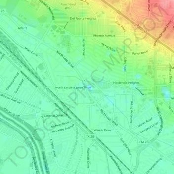
Name: Tigua topographic map, elevation, terrain.

Location: Tigua, El Paso, El Paso County, Texas, 79915, United States (31.72178 -106.38415 31.76178 -106.34415)

Average elevation: 1,135 m

Minimum elevation: 1,100 m

Maximum elevation: 1,210 m

Other topographic maps

Click on a map to view its topography, its elevation and its terrain.

Memorial Park

United States > Texas > El Paso County > El Paso

Average elevation: 1,167 m

Mc Arthur Park

United States > Texas > El Paso County > El Paso > Cielo Vista

Average elevation: 1,199 m

The Bite Food Park

United States > Texas > El Paso County > El Paso

Average elevation: 1,196 m

Gear up for your next adventure:

🦶Anti-Blister Balm - Prevents friction and hotspots during long ascents
💡LED Camping Lantern - Illuminate your campsite with long-lasting lanterns
👟Trail Running Shoes - Agile footwear for fast-paced topographic exploration
🧢Beanie Hat - Keep your head warm in cold weather
🧰Multitool Knife - Compact and versatile tool for outdoor use

As an Amazon Associate, this site earns from qualifying purchases at no extra cost to you.