Geolocate

Combe topographic map

Interactive map

Click on the map to display elevation.

Combe topographic map, elevation, terrain

Combe topographic map, elevation, terrain

About this map

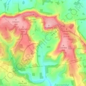
Name: Combe topographic map, elevation, terrain.

Location: Combe, West Berkshire, England, United Kingdom (51.32896 -1.49831 51.35813 -1.42971)

Average elevation: 215 m

Minimum elevation: 140 m

Maximum elevation: 299 m

Other topographic maps

Click on a map to view its topography, its elevation and its terrain.

Berkshire

United Kingdom > England > West Berkshire

All of the county is drained by the Thames. Berkshire divides into two topological (and associated geological) sections: east and west of Reading. North-east Berkshire has the low calciferous (limestone) m-shaped bends of the Thames south of which is a broader, clayey, gravelly former watery plain or belt from…

Average elevation: 100 m

Newbury

United Kingdom > England > West Berkshire

Elevations vary from a minimum of 72 m above mean sea level to 122 m at Wash Common. Elevations reach 150–200 m in the directly adjoining hills. The River Kennet and the Kennet and Avon Canal flow east through the centre of the town to reach the Thames at Reading, while the River Lambourn (beside which is…

Average elevation: 97 m

Winterbourne

United Kingdom > England > West Berkshire

Average elevation: 120 m

Reading

United Kingdom > England > West Berkshire > Reading

Mary Russell Mitford lived in Reading for a number of years and then spent the rest of her life just outside the town at Three Mile Cross and Swallowfield. The fictional Belford Regis of her eponymous novel, first published in 1835, is largely based on Reading. Described with topographical accuracy, it is…

Average elevation: 56 m

Mortimer

United Kingdom > England > West Berkshire > Mortimer

Average elevation: 80 m