
Morne Trois Pitons National Park topographic map
Interactive map
Click on the map to display elevation.
Morne Trois Pitons National Park
Most of the area of the park retains its natural habitat and there are a number of different vegetation zones, tropical rainforest, secondary forest, deciduous forest, montane rainforest, and dwarf forest. The large trees in the rainforest tower up to 30 and 40 m (100 and 130 ft) and have large buttress roots. The dominant tree is Amanoa caribaea, but Sloanea dengata, Sloanea caribaea, and Sloanea berteroana are also plentiful; Symphonia globulifera and Cecropia peltata have both massive buttresses and prop roots. The trees are interspersed with tree ferns and are swathed in epiphytes including orchids and bromeliads. At higher altitudes, the trees become smaller, and there are mountain palms, ferns, and hibiscus, while near the summits there is dwarf forest with low, branching shrubs, mosses, and lichens. In the Valley of Desolation, the sulphurous gases limits the vegetation, and there are Clusia mangle, grasses, and bromeliads.
About this map
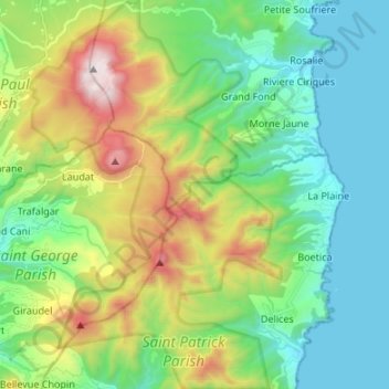
Name: Morne Trois Pitons National Park topographic map, elevation, terrain.
Average elevation: 410 m
Minimum elevation: -1 m
Maximum elevation: 1,378 m