
Make a donation
Gear up for your next adventure:
As an Amazon Associate, this site earns from qualifying purchases at no extra cost to you.
Imburana topographic map
Click on the map to display elevation.
Make a donation
Gear up for your next adventure:
As an Amazon Associate, this site earns from qualifying purchases at no extra cost to you.
About this map
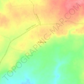
Name: Imburana topographic map, elevation, terrain.
Average elevation: 202 m
Minimum elevation: 158 m
Maximum elevation: 241 m
Make a donation
Gear up for your next adventure:
As an Amazon Associate, this site earns from qualifying purchases at no extra cost to you.
Other topographic maps
Click on a map to view its topography, its elevation and its terrain.
Jatobá do Piauí
Brasil > Piauí > Jatobá do Piauí
Localiza-se a uma latitude 04º46'16" sul e a uma longitude 41º49'04" oeste, estando a uma altitude de 240 metros. Área territorial: 664,51 km². Limites territoriais: norte: Milton Brandão, Capitão de Campos – Piauí; sul: (Sigefredo Pacheco) – Piauí; leste: Milton Brandão e Sigefredo Pacheco –…
Average elevation: 223 m