Geolocate

Taft topographic map

Click on the map to display elevation.

About this map

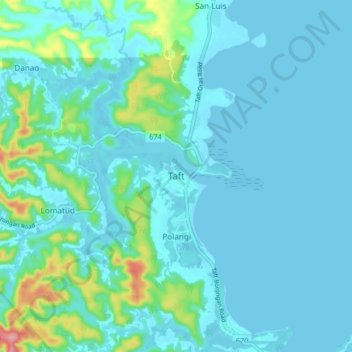
Name: Taft topographic map, elevation, terrain.

Location: Taft, Eastern Samar, Eastern Visayas, 6816, Philippines (11.86491 125.37642 11.94491 125.45642)

Average elevation: 17 m

Minimum elevation: -2 m

Maximum elevation: 119 m

Other topographic maps

Click on a map to view its topography, its elevation and its terrain.

Borongan City

Philippines > Eastern Samar

Average elevation: 11 m

Tikling

Philippines > Eastern Samar

Average elevation: 0 m

Hilabaan

Philippines > Eastern Samar

Average elevation: 1 m

Homonhon Island

Philippines > Eastern Samar > Culasi

Average elevation: 27 m

Calicoan Island

Philippines > Eastern Samar > Ngolos

Average elevation: 4 m

Manicani Island

Philippines > Eastern Samar > Banaag

Average elevation: 18 m

Homonhon Island

Philippines > Eastern Samar > Culasi

Average elevation: 27 m

Jipapad

Philippines > Eastern Samar

Average elevation: 110 m

Suluan Island

Philippines > Eastern Samar > Suluan

Average elevation: 12 m

Homonhon Island

Philippines > Eastern Samar > Habag

Average elevation: 27 m

Oras

Philippines > Eastern Samar > Jipapad

Average elevation: 37 m

Gear up for your next adventure:

🥾Trail Running Shoes - Lightweight and durable shoes for trail running
🦶Anti-Blister Balm - Prevents friction and hotspots during long ascents
🔦UV Flashlight - Detect minerals or specific insects in the dark
🛏️Sleeping Bag - Warm and compact sleeping bags for outdoor camping
🥘Camping Cookware Set - Compact nesting pots and pans for trail cooking

As an Amazon Associate, this site earns from qualifying purchases at no extra cost to you.