
Make a donation
Gear up for your next adventure:
As an Amazon Associate, this site earns from qualifying purchases at no extra cost to you.
Kilome topographic map
Click on the map to display elevation.
Make a donation
Gear up for your next adventure:
As an Amazon Associate, this site earns from qualifying purchases at no extra cost to you.
About this map
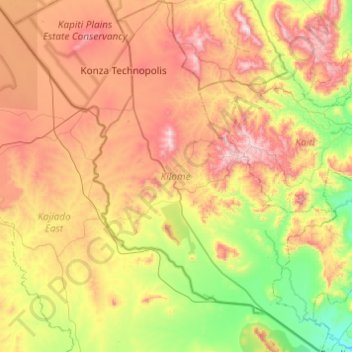
Name: Kilome topographic map, elevation, terrain.
Location: Kilome, Makueni, Eastern, Kenya (-2.07873 37.14271 -1.59138 37.48030)
Average elevation: 1,517 m
Minimum elevation: 1,105 m
Maximum elevation: 2,060 m
Make a donation
Gear up for your next adventure:
As an Amazon Associate, this site earns from qualifying purchases at no extra cost to you.
Other topographic maps
Click on a map to view its topography, its elevation and its terrain.
Make a donation
Gear up for your next adventure:
As an Amazon Associate, this site earns from qualifying purchases at no extra cost to you.
Make a donation
Gear up for your next adventure:
As an Amazon Associate, this site earns from qualifying purchases at no extra cost to you.
Makindu
Kenya > Makueni > Kibwezi West
Makindu has an altitude-moderated hot semi-arid climate (Köppen BSh) with very warm to hot afternoons and pleasant mornings throughout the year. Like most of Kenya, there are two rainy seasons: the “long rains” in March and April, and the “short rains” centred on November and December.
Average elevation: 993 m