
Thank you for supporting this site ❤️
Make a donation
Make a donation
Gear up for your next adventure:
As an Amazon Associate, this site earns from qualifying purchases at no extra cost to you.
Chesod topographic map
Click on the map to display elevation.
Thank you for supporting this site ❤️
Make a donation
Make a donation
Gear up for your next adventure:
As an Amazon Associate, this site earns from qualifying purchases at no extra cost to you.
About this map
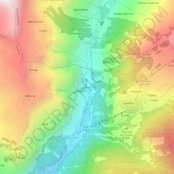
Name: Chesod topographic map, elevation, terrain.
Location: Chesod, Buisson, Antey-Saint-André, Valle d'Aosta, 11020, Italië (45.82295 7.58456 45.86295 7.62456)
Average elevation: 1,783 m
Minimum elevation: 1,060 m
Maximum elevation: 2,639 m
Thank you for supporting this site ❤️
Make a donation
Make a donation
Gear up for your next adventure:
As an Amazon Associate, this site earns from qualifying purchases at no extra cost to you.