Geolocate

Huancabamba topographic map

Click on the map to display elevation.

About this map

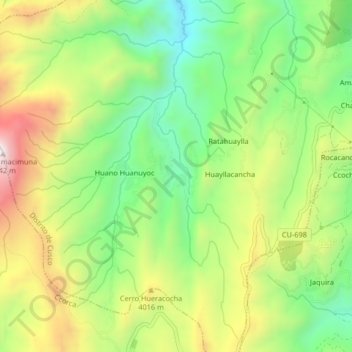
Name: Huancabamba topographic map, elevation, terrain.

Location: Huancabamba, Cusco, Distrito de Cusco, Cusco, 00801, Perú (-13.56305 -72.05021 -13.52305 -72.01021)

Average elevation: 3,913 m

Minimum elevation: 3,610 m

Maximum elevation: 4,326 m

Other topographic maps

Click on a map to view its topography, its elevation and its terrain.

Parque el Mapa

Perú > Cusco > Cusco

Average elevation: 3,375 m

Tampu Mach'ay

Perú > Cusco > Cusco > Huayllarccocha

Average elevation: 3,886 m

Gear up for your next adventure:

🧢Outdoor Visor - Breathable visor for sunny hikes
🧭GPS Outdoor Watch - Smart watch for navigation and fitness tracking in nature
🧥Thermal Fleece Jacket - Versatile insulation for changing mountain temperatures
🚑Survival Whistle - Signal for help across long distances in mountains
🦟Insect Repellent - Keep mosquitoes and black flies away in wooded areas

As an Amazon Associate, this site earns from qualifying purchases at no extra cost to you.