Geolocate

Wartrace topographic map

Click on the map to display elevation.

About this map
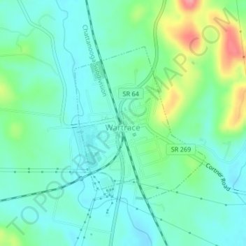
Name: Wartrace topographic map, elevation, terrain.

Location: Wartrace, Bedford County, Middle Tennessee, Tennessee, United States (35.51967 -86.34016 35.53647 -86.32242)

Average elevation: 261 m

Minimum elevation: 235 m

Maximum elevation: 334 m

Other topographic maps

Click on a map to view its topography, its elevation and its terrain.
Unionville

United States > Tennessee > Bedford County

Average elevation: 219 m

Flat Creek

United States > Tennessee > Bedford County

Average elevation: 272 m

Bedford

United States > Tennessee > Bedford County

Average elevation: 239 m

Weakly Creek

United States > Tennessee > Bedford County

Average elevation: 218 m

Daniel Hill

United States > Tennessee > Bedford County

Average elevation: 294 m

Gear up for your next adventure:

🥽Outdoor Goggles - Protective eyewear for outdoor activities
🧤Thermal Hiking Gloves - Grip-enhanced gloves for cold-weather altitude trekking
🧴Sunscreen SPF - Broad-spectrum sunscreen for outdoor activities
⛺Backpacking Tent - Lightweight tent for long-distance hiking trips
⛺Bushcraft Tarp - Versatile emergency shelter or gear protection

As an Amazon Associate, this site earns from qualifying purchases at no extra cost to you.